Kpali Gold Project
Highlights
- A 2024 review of Kpali Gold Project Geophysics and Historical Intercepts highlighted compelling scale-up opportunities.
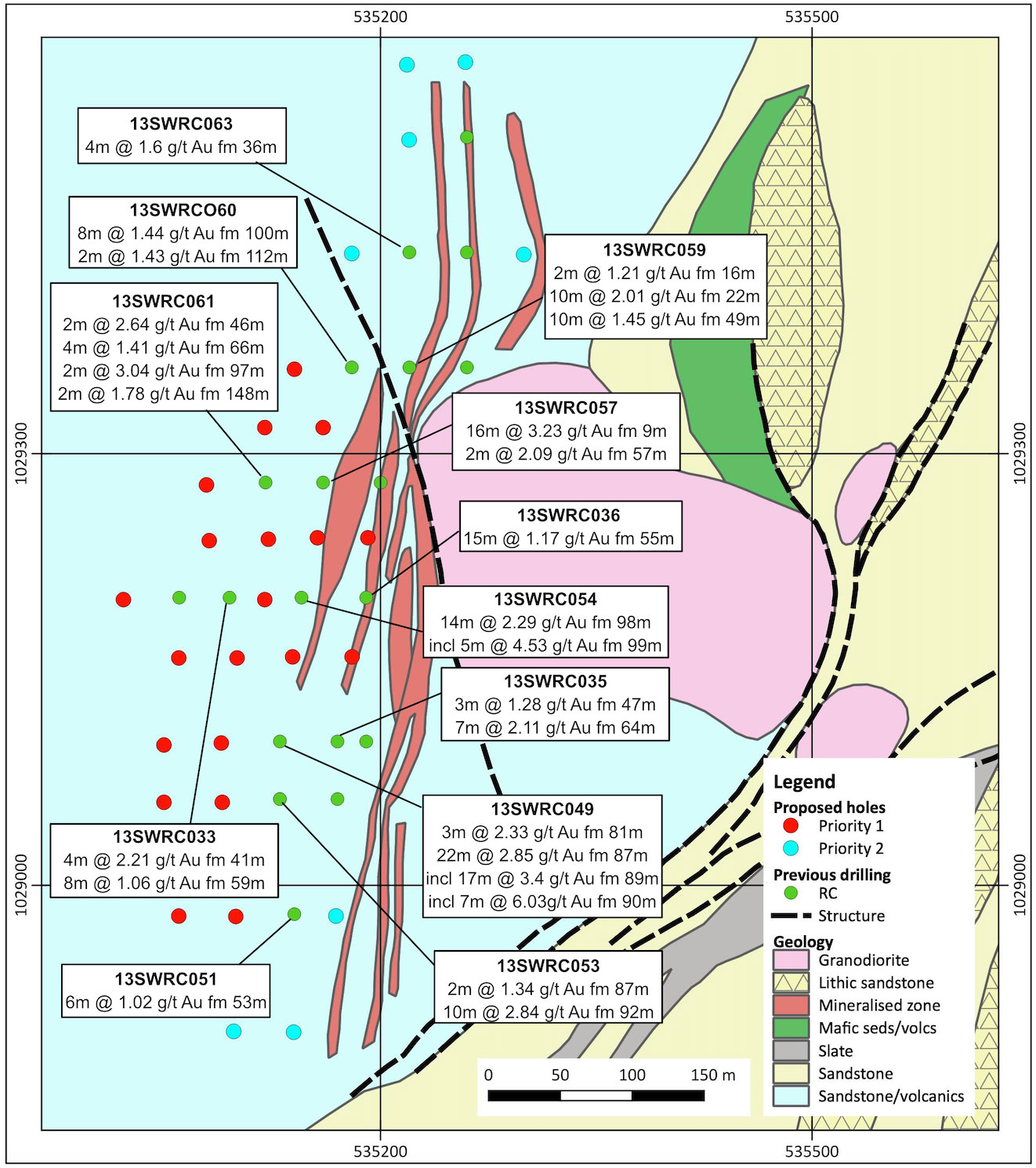
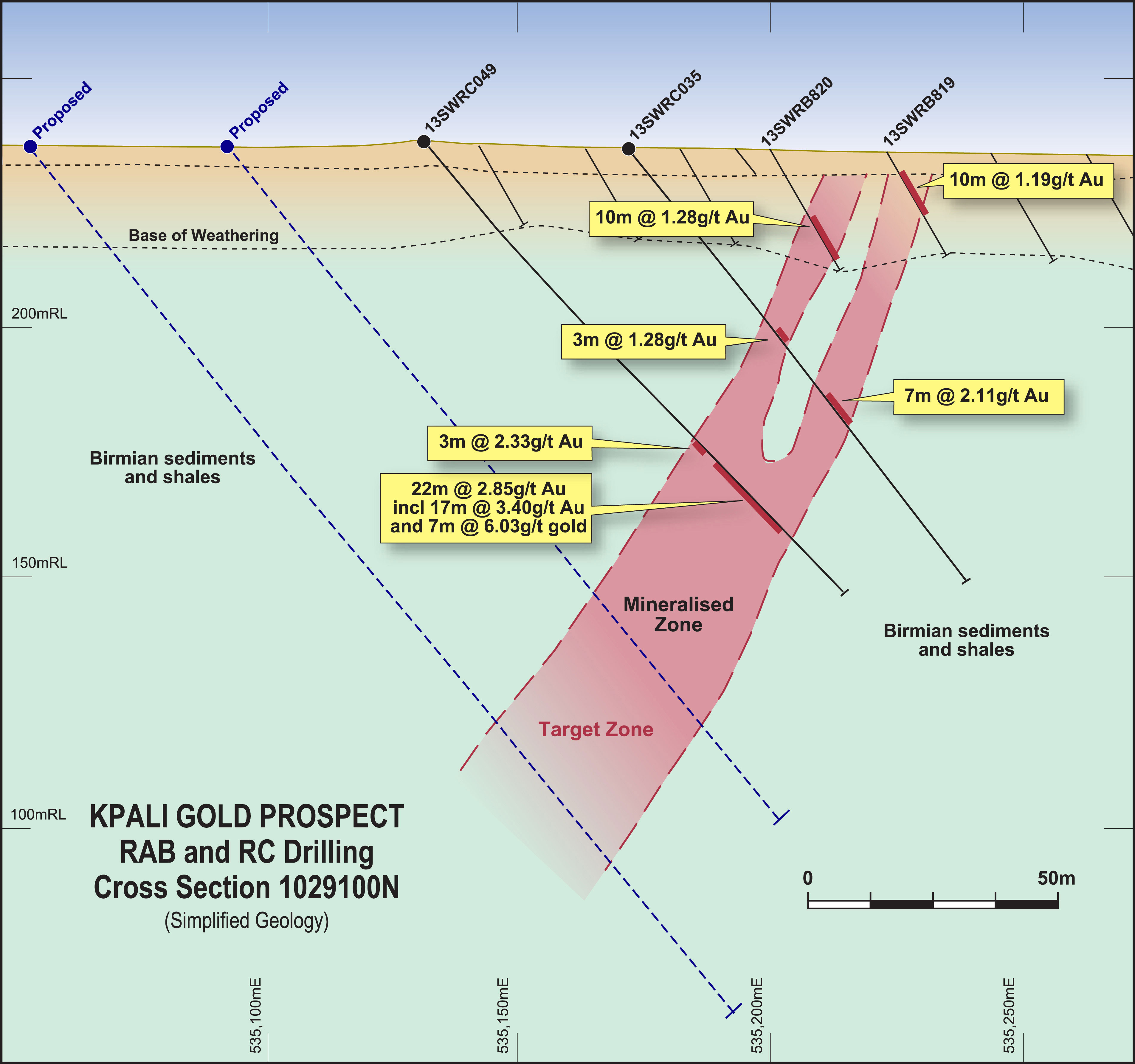
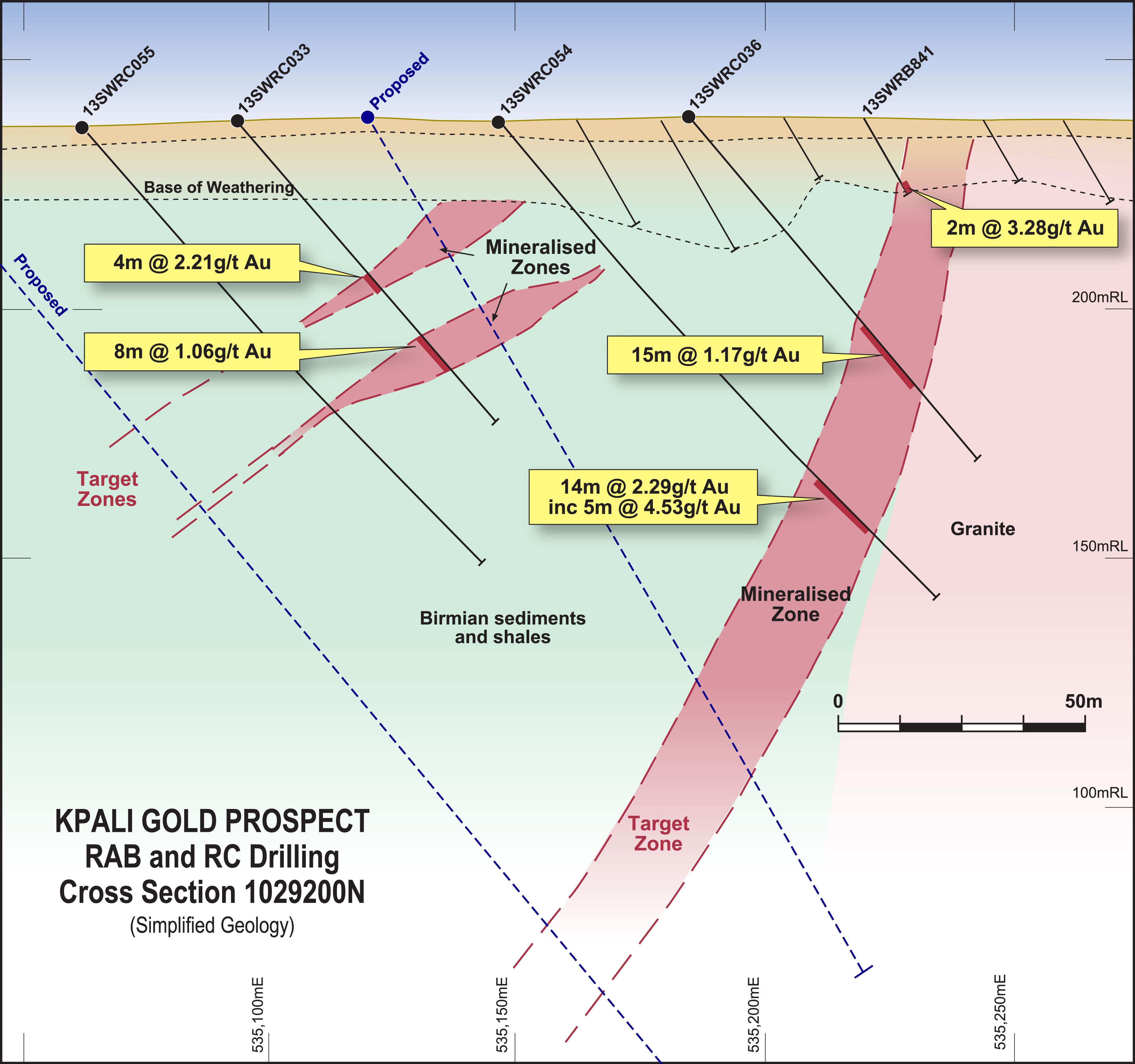
- 28-hole, 3,500m phased RC drill programme planned to extend mineralisation at 100% owned Kpali Gold Project, Ghana (refer ASX release 11 June 2024).
- First phase holes will test for downdip and strike extensions to previous Castle intercepts which included:
- 22m at 2.85 g/t Au from 87m
incl. 17m at 3.40 g/t Au from 89m
and 7m at 6.03 g/t Au from 90m (13SWRC049); - 10m at 2.84 g/t Au from 92m (13SWRC053);
- 14m at 2.29 g/t Au from 98m
incl. 5m at 4.53 g/t Au from 99m (13SWRC054); - 16m at 3.23 g/t Au from 9m (13SWRC057);
- 10m at 2.01 g/t Au from 22m and
- 10m at 1.45 g/t Au from 49m (13SWRC059).
- 22m at 2.85 g/t Au from 87m
- Subsequent drilling will further test Kpali plus several new targets in the immediate Kpali Gold Project area identified in reprocessed geophysics.
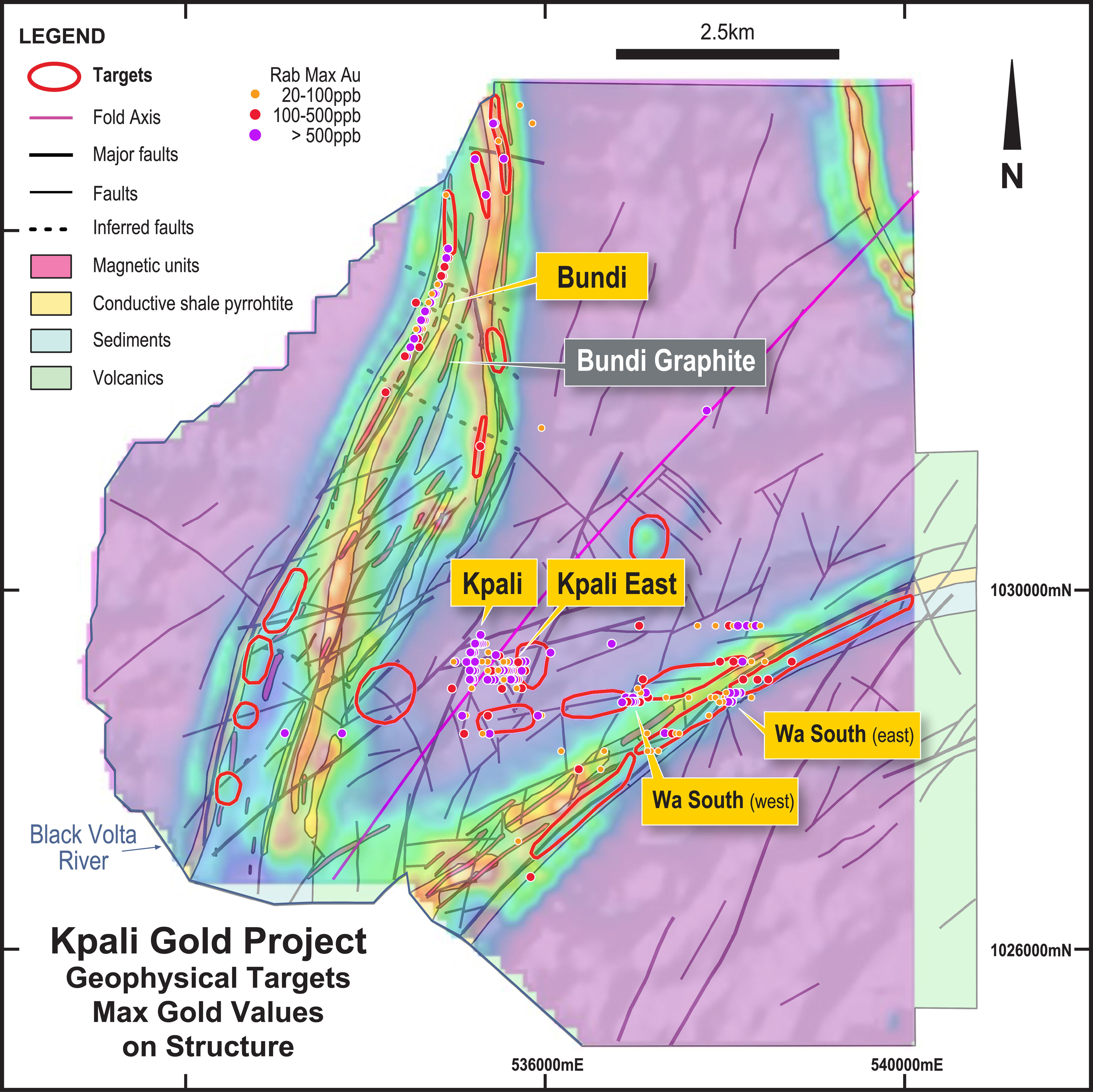
- Collectively the Kpali Gold Project, which includes the Kpali, Kpali East, Bundi, Wa South and Wa East prospects, infers the possibility of a new West African exploration camp.
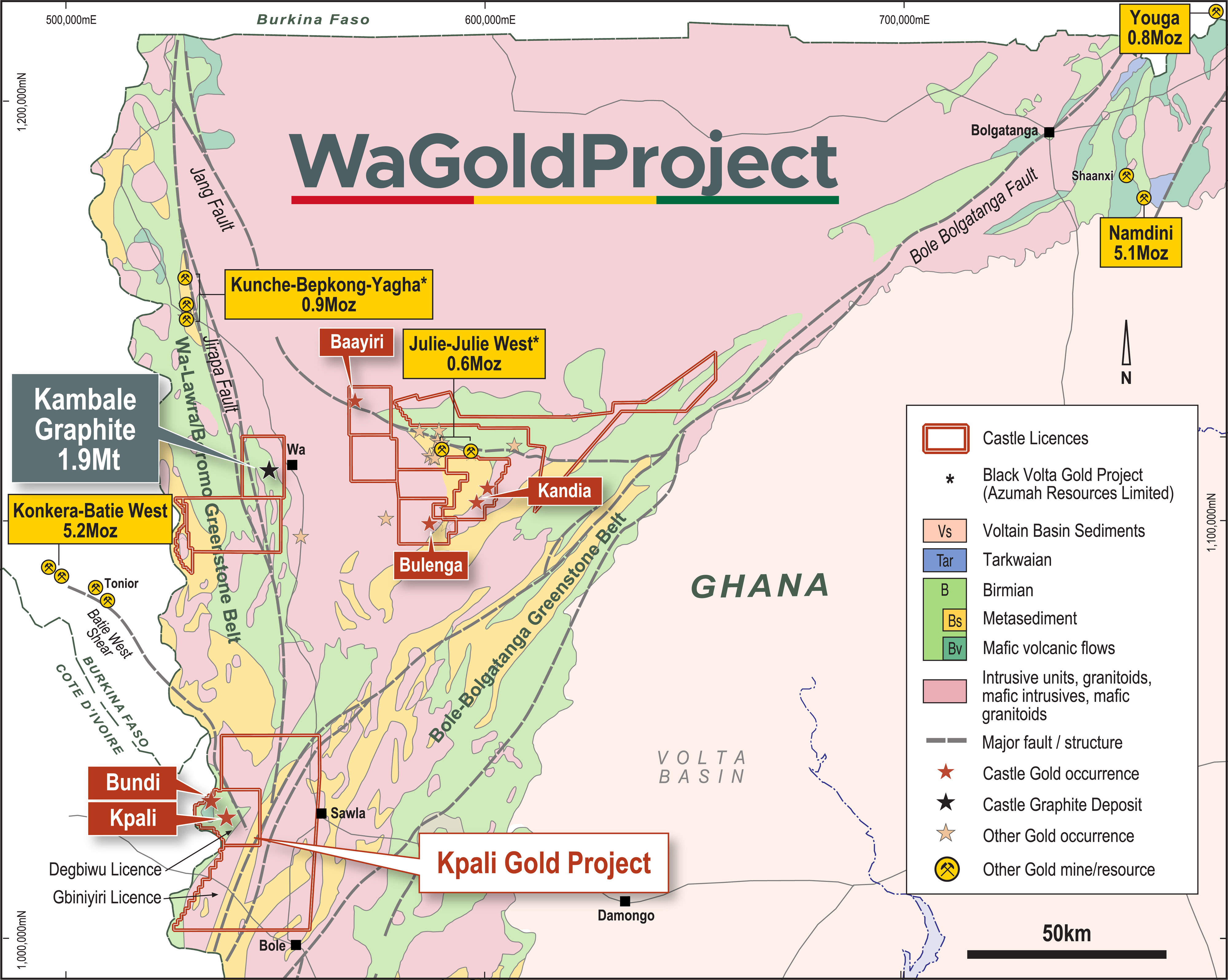
- Prospectivity greatly enhanced by convergence of two greenstone belts and three regional-scale structures individually associated with several major gold deposits (Konkere/Batie West, Black Volta, Namdini, Youga).
- Broader 2,686km² host Wa Gold Project includes several other discoveries.
- Wa Gold Project complements Castle’s nearby Kambale Graphite Project which is successfully moving into development study phase.
- Existing in-country technical team, exploration infrastructure and excellent stakeholder relationships facilitate timely and cost-effective exploration.
Background
The Kpali Gold Project comprises the Kpali prospect and the nearby Bundi prospect plus several satellite discoveries which lie ~30km west of regional town, Sawla. These prospects are situated within the 170km² Degbiwu prospecting licence (PL 10/26) which is surrounded by the 1,033km² Gbiniyiri retention licence (RL 8/27). The western border of each licence is the Black Volta River which also borders with Burkina Faso. Both licences are owned 100% by Castle through its wholly owned Ghanaian subsidiary, Carlie Mining Limited.
The main exploration driver, and original reason for investigating this area, is the extremely strong geological focal point provided by the convergence of two major greenstone belts (Bole-Bolgatanga and Wa-Lawra/Boromo) and three traversing regional-scale structures. These are individually associated with several major gold deposits and operating mines making Castle’s ground very compelling:
- 30km of the Batie West Shear, host to the 3.3Moz Konkera deposit (Centamin), 60km to the north west across the border in Burkina Faso;
- 15km of the Wa-Lawra shear zone, host to the 1.8Moz Kunche/Bepkong/Yagha deposits (Azumah Resources), 110km to the north and now awaiting a development decision; and
- 53km of the Bole-Bolgatanga shear zone, host to the 5.1Moz Namdini deposit (Cardinal Mining), 300km to the north east and which is about to commence mining.
- Castle is of the view that whilst very interesting in their own right, the Kpali Gold Project’s prospects, which also includes the Kpali East, Bundi, Wa South and Wa East prospects, may be indicative of a major gold “camp” hosting one or more large primary mineralised systems. These camps are typical of West African structurally-controlled orogenic gold environments and underpin the region’s status as one of the world’s most well-endowed gold regions.
- Gold anomalism and near-surface mineralisation, such as that already discovered at the Kpali Gold Project, provides a means to vector into and chase down-plunge major ore shoots which can extend to several hundred metres depth.
Castle is of the view that whilst very interesting in their own right, the Kpali Gold Project’s prospects, which also includes the Kpali East, Bundi, Wa South and Wa East prospects, may be indicative of a major gold “camp” hosting one or more large primary mineralised systems. These camps are typical of West African structurally-controlled orogenic gold environments and underpin the region’s status as one of the world’s most well-endowed gold regions.
Gold anomalism and near-surface mineralisation, such as that already discovered at the Kpali Gold Project, provides a means to vector into and chase down-plunge major ore shoots which can extend to several hundred metres depth.
Geochemistry
Several wide-spaced geochemical soil surveys in the region led to the Kpali Gold Project discoveries at Kpali, Bundi and elsewhere (refer ASX release 19 May 2011). A considerable area remains to be covered and/or infilled to identify additional anomalies or to finesse existing ones.
Geophysics
Reprocessing and interpretation of Castle airborne VTEM and ground magnetics geophysical surveys by Perth-based consultants, Terra Resources P/L, has identified an array of conductors and magnetic anomalies which have been prioritised for follow-up for the location of mineralisation. Nine ranked as higher priority will inform Castle’s longer term exploration strategy.
Kpali Prospect
Kpali was a virgin discovery in 2013 arising from systematic wide-spaced RAB drilling and power-auger geochemical sampling beneath a veneer of transported soil cover. Some 2,711 RAB holes have been drilled in the Kpali-Bundi area.
During 2013-2014, 20 RC holes drilled on eight sections delineated a mineralised corridor associated with a ~30m to 50m wide zone of structural deformation (refer ASX release 18 January 2014).
The drilling returned a series of wide, high-grade intercepts and confirmed the presence of hydrothermal lode-style mineralisation over a combined strike of at least 850m and to a depth of 100m. Better intercepts included:
- 22m at 2.85 g/t Au from 87m
incl. 17m at 3.40 g/t Au from 89m
and 7m at 6.03 g/t Au from 90m (13SWRC049); - 10m at 2.84 g/t Au from 92m (13SWRC053);
- 14m at 2.29 g/t Au from 98m
incl. 5m at 4.53 g/t Au from 99m (13SWRC054); - 16m at 3.23 g/t Au from 9m (13SWRC057);
- 10m at 2.01 g/t Au from 22m
and 10m at 1.45 g/t Au from 49m (13SWRC059); - (refer ASX release 11 June 2024)
The geology at Kpali is dominated by low-grade metamorphosed sediments and volcaniclastics, with a lesser amount of mafic volcaniclastics. This sequence is intruded by a coarse-grained felsic circular body that demarcates the eastern boundary of the mineralisation.
Mineralisation runs north-south, is generally steeply dipping and occurs as a number of distinct, individual, more or less planar-lodes, that vary between 2m to 20m in thickness. These lodes are mostly continuous and were consistently intersected in drilling along an established central trend of some ~500m that remains open to the south and possibly also to the north.
Following several phases of drilling, an initial Mineral Resource was estimated for Kpali which was reported in accordance with JORC Code 2012 and comprised 2.91Mt at 1.1g/t Au, all of which is in the Inferred Mineral Resource category (refer ASX release 2 July 2014).
Castle’s proposed RC drilling will initially focus on this highly prospective central trend and area of the initial Mineral resource estimate with a view towards firmly establishing Kpali’s credentials to deliver a sizeable and robust ore-body.
Kpali East Prospect
The Kpali East prospect, 500m east of Kpali, was identified by soil sampling and regional RAB drilling undertaken in 2013 and 2014 to follow-up the Kpali discovery and to test a de-magnetised zone delineated by interpretation of historical aeromagnetic data acquired by Castle.
The RAB intercepts overlie the east side of the Kpali granite and are aligned with the de-magnetised corridor which trends east-southeast across the southern portion of Castle’s licence area. Initial follow-up with RC drilling in mid-2014 produced some encouraging anomalous intersections. Further work is required.
Bundi Prospect
The Bundi prospect, situated 4km north-northwest of Kpali, was discovered in 2013 by Castle following reconnaissance soil sampling, auger drilling and RAB drilling. RC drilling was undertaken later in 2013 and 2014 with 16 of 20 RC drillholes reporting mineralisation and a best intercept of 51g/t Au over 1m.
Interestingly, there also appears to be an association of zinc sulphides with the gold mineralisation (refer ASX release 23 May 2013) suggesting that Bundi may represent the distal expression of a volcanogenic massive sulphide horizon. This is not unsurprising as the Perkoa zinc mine lies on the same Wa-Lawra / Boromo greenstone belt where it extends to the north into Burkina Faso. Further exploration and study work is required to verify this hypothesis but is not a priority at present.
The Bundi prospect comprises linear, continuous vertically dipping mineralisation over a strike of ~1,400m and to at least 100m depth. It remains open in both directions.
It is hosted within altered Birimian shales and sediments. Gold mineralisation is associated with quartz-sericite schist (metamorphosed felsic volcanic) with sericite alteration and 1-3% disseminated sulphides (incl. sphalerite).
Better gold intercepts from the RC drilling at Bundi included (refer ASX release 17 June 2013 and 29 April 2014):
- 4m at 2.57g/t Au from 24m (13SWRC026);
- 6m at 3.32g/t Au from 37m (13SWRC027);
- 8m at 2.16g/t Au from 40m (13SWRC028);
- 2m at 9.09g/t Au from 68m (13SWRC032); and
- 5m at 1.40g/t Au from 209m (14SWRC066)
Graphite at Bundi
Graphite was intersected in the vicinity of the Bundi gold discovery during drilling directed specifically for gold mineralisation. Several near-surface, weathered, relatively (to Kambale) lower grade zones trend sub-parallel to gold anomalism and mineralisation. Further work is required to appraise the material at depth and into the unweathered, primary zone (refer ASX release 30 July 2014).